Find Me On...


De Legione Romana is an open space, created for deepening the own knowledges and to actively participate.
The immediateness of the publication doesn't allow preventive filters, so utility depends from your collaboration and from the good sense.
How to use the Roman groma
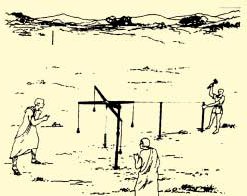
In the building of a Castra, after having flattened the ground and before starting the ditch and wall construction, an agrimensor (land surveyor) drew the locations of the streets and of the wall, beginning from the center of the field, using the groma. It follows the description of this topographical tool and its use. The original and full version was writed by Edilio Boccalieri, and it is available here.
Introduction^
Groma is the principal tool used by the Roman surveyors to trace on the ground simple and orthogonal alignments, necessary to the construction of roads, city, temples and agricultural lands subdivision.
According to the linguists the groma term derives from the correspondent Greek term gnoma, but there is who makes it derive from a-grumus (field without heaps), that is the plan where they used the groma.
Description^
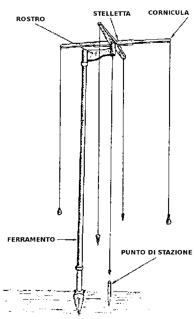 Groma composition
This topographic tool is composed by three fundamental parts:
- Stelletta it is formed by two equal arms, cross and forming right angle, made in hollow metal with reinforcement of a soul in wood; from the four extremity, called curnicula, four threads (plumb lines) fall suddenly down with cone-shape or pear-shape coupled weights;
- Rostrum, is a strong pole with the cylindrical extremities: one to receive the swivel pivot of the stelletta, the other for the grafting in the vertical pole; the distance among the two cylinders measure exactly a foot (0,2963 m);
- Ferramento, it is a pole in hollow metal able to support the preceding parts, equipped in the inferior extremity with metallic cone-shape point, for the fixing.
The groma was positioned with the ferramento in vertical position, using the plumb lines, to verify the parallelism. Through a fifth plumb line they centered the stelletta with the station point.
The point could be hammered in the ground or ad lapidem, a particular stone that the surveyors brought with themselves.
In this way the groma was ready for use.
The plumb lines falling from the cornicula constitute two copies of finishing lines, the use of the groma consisted of contemplating the various points of the ground through these virtual lines.
Tracing of a simple alignment among the points A and B^
Groma was fixed in station in A point, in the B point was planted the meta. Then they rotated the stelletta so as to reach, through a couple of finishing lines, the destination in B. They planted along the direction of this view different metae, getting the layout of the alignment. This was the basic procedure for all the operations with the groma.
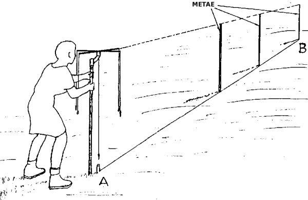 Simple alignment
Tracing of a orthogonal alignment^
Fixed the first alignment A-B, the groma was set in station in the intermediary C point, intersection of the two directions that will be traced.
Then rotating the stelletta they established the direction on the metae in A and in B through the first couple of finishing lines. After having fixed the stelletta, they contemplated, through the second couples of finishing lines the other two points, D and E follow the basic procedure. This was the most frequent case in the use of the groma; it concerns the tracing of the ecumani of the cities or the camps and for the assignment of the lands to the inhabitants of the cities and the colonies.
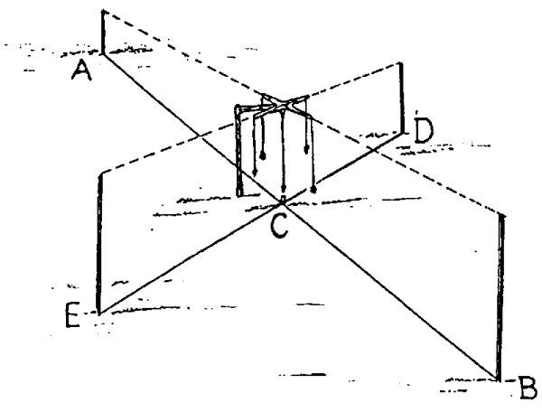 Orthogonal alignment
Finding the distance of an inaccesible point on the ground from station point^
They positioned at first the groma in the A station point and they centered the inaccessible point B with the first couple of finishing lines. Then they established an orthogonal alignment to the line AB, through the other couple of finishing lines, determining the point C to a certain distance from A. With groma in C they established C-D, an orthogonal alignment to A-C. They divided the length A-C in two equal parts and they settled the groma in the middle point E. Prolonging the alignment B-E up to the meeting with C-D line, the intersection gives F. The found distance (C-F) is equal to the looked for one (A-B).
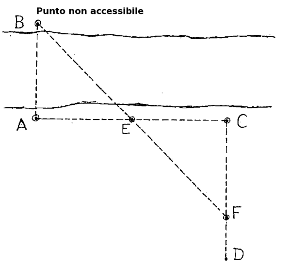 Distance of an inaccesible point on the ground from station point
This procedure was applied for calculating the width of the rivers, the extension of the marshes and the swamps, the distance of the ships in approach to the harbors.
Besides with the groma they noticed the data for draw the ground form, a topographical draft, directed with the help of the portable gnomone (reduction of the great solar clocks).
A model^
At the following link, it is possible to see a reconstructed and working Groma, made by Stilarte for Opera Laboratori Fiorentini, 1999. Link: POMPEI - SCIENZA
Sources^
- Edilio Boccalieri, L'uso della Groma in età romana, tratto da Esperienze e Progetti n. 125 (file PDF: http://www.baden-powell.it/ep/125/Groma.pdf)
Changelog^
- (11/03/2006) First version